Jim Cantore: Intrepid Weather Channel reporter almost wiped out by flying branch during Hurricane Ian

PUNTA GORDA, FLORIDA: Hurricane Ian swamped the southwest Florida coast with water and smashing trees on Wednesday, September 27. Unleashing catastrophic flooding and minacious winds, the monster storm made landfall near Fort Myers, Florida. But all this destruction caused by the colossal storm was not enough to stop meteorologist Jim Cantore from doing his job.
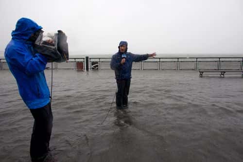
Cantore, who is known for his reports from the scene of some of the most vicious storms in the US, was at ground zero to cover the destruction caused by Hurricane Ian, from Punta Gorda, about 20 miles away across Charlotte Harbor. But the assignment had breathtaking risks of its own.
READ MORE
Tropical Storm Claudette: Flash flood warning for Mississippi, Alabama, Florida
Battling the howling winds of Hurricane Ian, Cantore was religiously doing a live man-on-the-street report when he got struck by a flying tree branch, which hit him in the leg and knocked him over. The footage shared by Joel Franco gave a clear indication of how hard it was for Cantore to stand up straight and dodge debris. "You know what, I think I’m just going to come in here for a second," Cantore said on the Weather Channel stream as he struggled to grab a street sign. "Just give me a second. I’m fine," he added.
Jim Cantore literally hit by a flying tree branch during a live report. Please get this man off the street. pic.twitter.com/D6UOizGArc
— Scott Gustin (@ScottGustin) September 28, 2022
In a later clip, Cantore was seen saying: ”We have come up here for safety from the surge…and where we were earlier, it looks like there’s three or four feet of water. Waves crashing over the area from earlier this morning.” He continues, “This is one of the worst hurricanes I have ever been in. It may be the worst in terms of covering over 25 years and 90 storms. “It looks like a North Atlantic Ocean storm here in Fort Myers,” the meteorologist said while hinting at the waves coming closer to the building, where he took shelter “The ocean, the river, and the gulf has taken over everything.”
We're officially in the thick of things.
— The Weather Channel (@weatherchannel) September 28, 2022
Our coverage of #Ian continues on The Weather Channel. @mikeseidel gives an update from Fort Myers, Florida: pic.twitter.com/8PKjGLBKZz
In the eye wall of #Hurricane #Ian in Fort Myers. We're live on @weatherchannel along with @StephanieAbrams and @JimCantore #HurricanIan pic.twitter.com/gSBdmAUjWX
— Mike Seidel (@mikeseidel) September 28, 2022
There's a saying that goes "If Jim Cantore's in town, you shouldn't be." Considered one of the best in business, Cantore garnered a cult among the audience following his daring coverage of hurricanes and other major weather events. The meteorologist has been working with the weather channel since graduating from Lyndon State College in 1968.
What makes him a star weather reporter is his ability to break down complex scientific term into layman's language to give his audience a better context of the situation. He is also featured front and center in some of the wildest weather footage ever captured. Apart from weather reports, he also rose to fame with his occasional sit-ins for Al Roker on The Today Show.
However, coming back to Hurricane Ian, the Category 4 hurricane was registering winds of 150 miles per hour as of 2.10 pm. The storm was heading inland, where it was expected to weaken, but residents in central Florida could still experience hurricane-force winds. The local emergency managers have already asked residents to evacuate the area near Punta Gorda, which also took a direct hit from Hurricane Charley back in 2004. The storm previously tore into Cuba, killing two people and bringing down the country's electrical grid.


