Will Hurricane Sam make US landfall? Category 4 storm strengths in the Atlantic

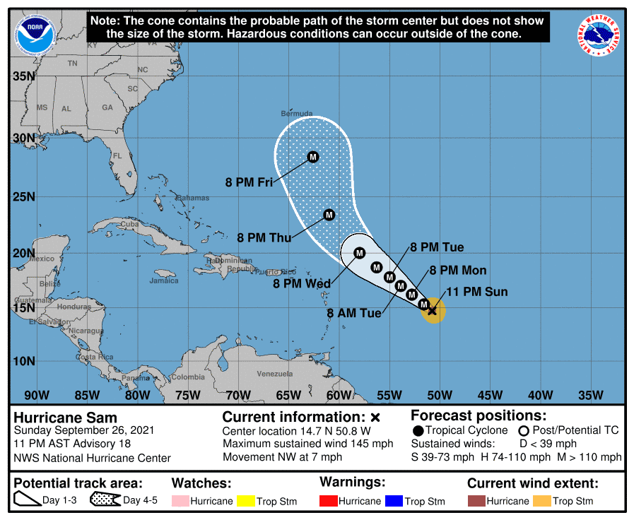
Storm watchers are keeping a close eye on Hurricane Sam, a category 4 storm that is currently over the Atlantic ocean. With wind speeds of up to 150 mph, the storm is currently moving "slowly" across the ocean and has been labeled as "small but dangerous" by the National Hurricane Centre. Even though it has formed well out in the Atlantic, experts have their eye on the storm because there's a chance it could come very close to the US mainland, if conditions are right as they were for Hurricane Sandy in 2012.
Sam is the 18th named storm to form this season, which has already seen devastation like no other. Hurricane Ida ripped through several states in late August and early September, leaving amongst other things subway lines in New York City flooded. Newark airport was also forced to suspend flights after floods ravaged the terminal, effects rarely seen in New York and New Jersey. The hurricane also led to tornadoes in Maryland, as we reported on September 1.
RELATED ARTICLES
2021 Atlantic Hurricane Season: Full list of storm names and what to expect
Hurricane Ida forces Mississippi river to 'flow backwards' in epic fury of nature
With several states still rebuilding after the deadly hurricanes of the past few months, we could be in for some bad news when it comes to Hurricane Sam. Forecasts expect it to remain well North East of the Leeward Islands, but one expert noted that there is also a possibility of "Sam to get very close to the US".
Will Hurricane Sam make landfall in the US?
Most predictions believe Sam will avoid the US mainland. As of September 26, the hurricane reached top speeds of 145 mph, beaten only by Ida's 150 mph+ speeds. Yale's Climate Collections described Sam as an "exceptionally healthy hurricane", so it is unlikely to just die down. It was also classified as a cat 4 storm, upgraded from its original cat 1 classification. Together, those indicate that Sam will indeed be a very deadly hurricane, with effects as deadly as Ida's.
The good news is though, that Sam may not come anywhere close to the US. The National Hurricane Centre expects Sam to continue on its path North West, before turning northwards towards Bermuda. Predictions show that by Friday, October 1, the eye of the storm will be over the island nation, well away from the US mainland. As a result, the center issued a public advisory on September 26 saying, "There are no coastal watches or warnings in effect."

Speaking to USA Today, AccuWeather meteorologist Bernie Rayno did however urge some caution. He said a dip in the jet stream would steer Sam away from the US. "But if that jet stream dip sets up farther west or meanders westward, then there is room for Sam to get very close to the U.S. next weekend," he added. That's exactly what happened in 2012, leading superstorm Sandy to slam into New Jersey resulting in overt $70bn in damage.
While that scenario isn't likely for Sam, the AccuWeather team did warn a "range of scenarios" were possible. "Even if Sam remains east of the U.S. late this week through next weekend, seas (could rise) along the Atlantic coast from central Florida to Maine with building surf and increasing rip currents," another meteorologist Rob Miller added. Making landfall though seems to be a distant possibility.
Behind Sam, the hurricane center has also tracked two disturbances that have a 70% chance of turning into cyclones. If they do, they'd likely be named Victor and Wanda.


