Hurricane Ida: National Hurricane Center warns of storm surges up to 12 feet

As Hurricane Ida continues to rage on The National Hurricane Center was warned of surge effects across Louisiana to the Alabama/Florida border, including Vermilion Bay, Lake Borgne, Lake Pontchartrain, Lake Maurepas, and Mobile Bay.
With winds at 150mph, Hurricane Ida might be fast approaching the status of a Category 5 hurricane. And with it comes the risk of a storm surge, which is known to cause further property destruction and endanger lives.
READ MORE
Will New Orleans levees hold? Hurricane Ida may devastate 'outlying' areas
More than 100 dogs and cats flown out of Ida path to California, Texas for adoption
What is a storm surge?
As per the Hurricane Ida Advisory Number 14 Bulletin issued by The National Hurricane Center, "A Storm Surge Warning means there is a danger of life-threatening inundation from rising water moving inland from the coastline in the indicated locations." It is a situation where there is an abnormal and sudden rise in ocean levels due to a storm. Surges result in ocean water moving inland due to the force of the wind.
The centre has also warned that it is a "life-threatening situation", and that people located in the area should take necessary actions to protect themselves from the rising water as well as follow evacuation and other instructions from local officials.
The tide gauge in Shell Beach, Louisiana, is at a water level of 6.4 feet which is the approximate level of inundation in that area, while the tide gauge at Bay Waveland Yacht Club, Mississippi, is at a water level of 5.5 feet, as reported by National Oceanic and Atmospheric Administration.
However, as per the bulletin, Port Fourchon to Mouth of the Mississippi River, Morgan City and Bay St. Louis, MS might see surges as high as 8 to 12 feet. While other parts of the hurricane's landfall can expect to see surges between 3 feet to 8 feet.
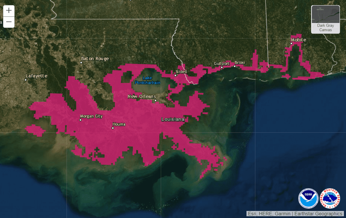
While New Orleans has leeves in place to deal with said surges, only time will tell if they will be able to survive Hurricane Ida. As per the NOLA report, the greater New Orleans area has a much larger levee protection system in place; however, Jean Lafitte, Barataria and Lafitte's levee stands at 7½-feet. Should Hurricane Ida bring in a higher surge, it could spell destruction for the entire area. "Anything over 7½, eight-foot would be complete and utter devastation," said Tim Kerner Jr, the mayor of Jean Lafitte. "It'd be a historic storm in the worst possible way for the Town of Jean Lafitte, Crown Point, Lower Lafitte, and Barataria, all of south Jefferson outside the levee protection."
FEMA has also listed a range of resources on their website, all of which can be accessed via this link. In addition, the website also offers Louisiana residents storm updates via text - message "IDA" to 67283.


