When will Tropical Storm Fred make landfall? Florida to face less impact than feared

The National Weather Service and Hurricane Centre have asked Floridians to prepare for heavy storms in the coming weeks, with the Tropical Depression Fred expected to strengthen into a full-fledged storm. Fred will be followed by Tropical Depression Seven, which is also expected to turn into Tropical Storm Grace. If that happens, Fred will be the sixth, and Grace the seventh hurricane in the Atlantic.
The hurricane season in 2021 is one of the worst the US has seen, with several storms already leaving devastating effects. On August 1, we reported on massive flooding in Utah, that turned Salt Lake City into a "river." In June, we also reported on Tropical Storm Claudette, which led to flash flood warnings for Mississippi, Alabama, and Florida. The conditions are only expected to get worse, as a study found that the East Coast may see more flooding in the years to come.
RELATED ARTICLES
2021 Atlantic Hurricane Season: Full list of storm names and what to expect
As we have previously covered, Tropical Storm Fred is set to hit the Florida panhandle, leading Governor Ron DeSantis to urge residents to "review their disaster plans." Initial projections indicated that the Florida Keys would be one of the worst-hit, followed by mainland Florida but new data indicates a change in path.

When and where will Fred make landfall?
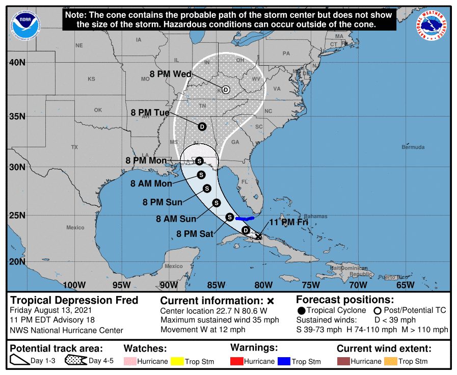
According to the most recent data, TS Fred's path has shifted further west, indicating it may not cause as much damage to mainland Florida. According to the latest projection from NOAA, TS Fred will make landfall in the Flordia panhandle, before moving into Georgia, Alabama, and Mississippi. Nonetheless, the National Hurricane Center has put out a heavy rainfall and flood advisory for Southern and Central Florida. On August 11, the storm weakened to a depression as it dumped vast quantities of rain around the Dominican Republic.
As of August 13, Fred's wind speed was monitored at 30 mph, but it may reach around 40 mph later in the night. The storm is expected to make landfall around Saturday (August 14) morning with winds as high as 45 mph. That has to lead to warnings for the regions from Key Largo to the Dry Tortugas and Florida Bay. By Sunday (August 15), the storm could reach as far north as Dothan, Georgia, where winds are expected to be in excess of 60 mph. The Bahamas are also expected to see some heavy winds, around 35 to 40 mph late on August 13 as Fred makes its way towards the mainland. By Monday, August 16, Fred will be felt in northern Mississippi, Alabama, Georgia, and even southern Tennessee.
Behind Fred, TD Seven was 775 miles east of the Leeward Islands and is reported to be following the same path as Fred. It is expected to hit the mainland sometime around Wednesday, August 18. Residents are urged to keep up with the latest updates wherever they can, and take all necessary precautions. Fred is the first Atlantic storm in August, and the first since Hurricane Elsa made landfall in July.


