Scientists have mapped a fifth of Earth's ocean floor, here's how it may help in understanding climate change

Covering more than 70% of the Earth, oceans are home to many mountains, diverse marine life, and a wealth of mineral resources -- most of which continue to remain a mystery to this day. In fact, scientists have a better understanding of surfaces on Mars and the Moon than of the vast expanse of our planet's water bodies and the ocean floor, which has cost us a great deal. For instance, it could have helped authorities locate the whereabouts of the MH 370 Malaysia Airlines flight that went missing in the wee hours of March 8, 2014. It could have also prevented the submarine USS San Francisco from crashing into a sea mountain in 2005 and, perhaps, several other such incidents. Mapping the seafloor has applications that stretch far beyond avoiding accidents -- from understanding climate change and tsunamis to the management of fisheries.
Enter Seabed 2030, a project with an ambitious plan of mapping the complete ocean bed by 2030. Recently, they announced completing work in a fifth of the oceans. Jamie McMichael-Phillips, the Project Director, said that this collaborative initiative between the Nippon Foundation of Japan and the General Bathymetric Chart of the Oceans (GEBCO) -- could help the world make policy decisions, use ocean sustainability, and undertake scientific research. Mapping, by no means, is an easy task. "A single vessel, operating at the sea surface, would take close to 1000 years to map the entirety of the rest of the ocean," Dr Vicki Ferrini, who is involved in the project, told MEA WorldWide (MEAWW). She is a research scientist at Columbia University and an Affiliate Associate Professor at the Center for Coastal and Ocean Mapping at the University of New Hampshire.
The project roped in international scientists with the hopes of speeding up the mapping process. "I think one of the exciting aspects about this project is we are really bringing together the global community of people and experts that work in this space and building this new way of working together and sharing data and integrating into globally useful products that can be shared with the world," she explained. Mapping the shape of the seafloor is really just the beginning, explained Dr Ferrini, adding that it helps lay a foundation for future work. Based on the data from the map, scientists might be able to deploy a robotic vehicle to dive into the oceans and collect samples. They might be able to develop a better understanding of the habitats of marine organisms and understand how to efficiently manage fisheries. "All of that first starts with a map. So we're really trying to get this baseline to start. And then there's so much more we can do after that," she explained.
Why is it hard to map the oceans?
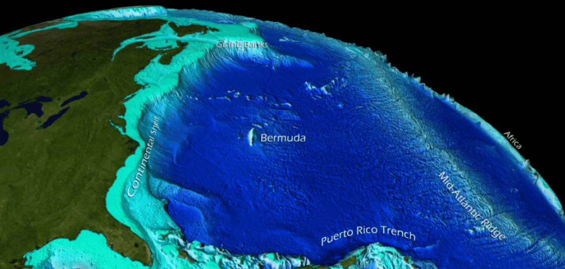
On land, scientists used satellites to map land topography, but light and radar are fast rendered weak by water, Dr Martin Jakobsson, from Stockholm University and the co-head of the Seabed 2030 Arctic and North Pacific Ocean Regional Center, told MEAWW. It is hard to map the oceans because water comes in the way, hence experts use echo-sounders, which they attach to the ships. Echo sounders use sound to determine the depth of the oceans. In other words, scientists measure the time the sound waves take to hit the ocean bed and return to the ship. The whole process is expensive and time-consuming, Dr Ferrini, added.
Dr Jakobsson also agreed. Moving around and mapping the floor using echo sounders simply takes time, even with modern technologies such as the multi-beam echo sounders. "Also, areas of the World ocean are difficult to access for vessels due to heavy sea ice, like around Antarctica and in the Arctic, and some areas are simply very remote, like parts of the Pacific and Southern Ocean. In the end, it is a matter of resources dedicated to the task. It is doable with modern techniques and vessels," he said. As ships move, they collect snapshots of the ocean floor and then stitch those pieces together to see the shape. "We think of it like mowing the lawn or kind of sweeping just back and forth," she said. The next step is to clean the data to get an accurate picture of the bed.
Climate change and more
The map could help scientists understand the rate at which big ice sheets -- the Antarctic ice sheet and the Greenland ice sheet --melt in response to a warming climate. "This, in turn, is crucial to estimate their contribution to global sea-level rise," Dr Jakobsson said.
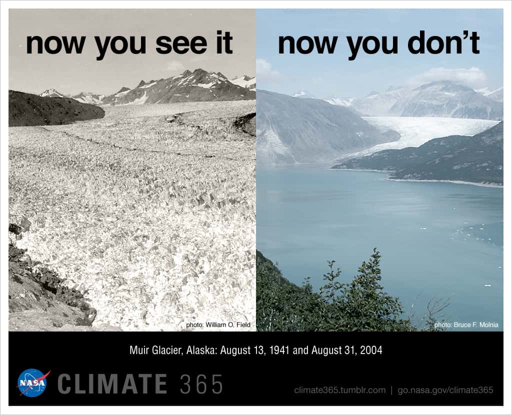
It could explain how glaciers respond to climate change. For instance, many Alaskan glaciers have retreated and thinned dramatically since the 19th century. A similar scenario is playing out in Greenland and Antarctica. When the land-based ice melts, it could contribute to the global sea-level rise. Influencing the retreat is the inflow of warmer water. Understanding the ocean floor can help ocean scientists understand which of these glaciers are vulnerable to warm water, according to Dr Jakobsson. The other part where ocean floor mapping can find applications is studying ocean currents, which distributes warm seawater from the equator to the poles and cold water from the poles back to the tropics.
"Ocean currents are going to respond to the shape of the seafloor. If you think about weather and storms, hurricanes, tsunamis -- those are all going to respond in some way to the shape of the seafloor," Dr Ferrini said. Regions with shallower waters are usually warmer, and they can, in turn, help feed the hurricanes and strengthen them. What is more, scientists can understand how tsunamis propagate and actually hit the coast. There are other reasons to map the oceans too. "The first obvious reason to map is for the safety of navigation. We need to make sure that all the vessels that are out there know where they're going. There have been examples of submarines hitting sea mountains," Dr Ferrini said. It could also assist in recovery operations, such as finding missing flights. Further, the shape of the seafloor can identify fishing hotspots. Based on the data, authorities can enforce regulations.
Ocean mining concerns
The seafloor contains a plethora of minerals, including copper, zinc, nickel, gold, silver, and phosphor. Of special interest to miners are precious metals, rare earth elements, and even diamonds. “It’s like the old Klondike [Gold Rush], but the streams lead to the ocean,” Steven Scott, professor of geology at the University of Toronto and consultant to the marine mining industry, told Smithsonian Magazine. “There’s mining for diamonds off of Southern Africa, tin deposits off of Indonesia, gold off Alaska," he added.
Ecologists fear that miners will exploit the map and damage the marine environment. “We know so little about potential environmental impacts” of ocean mining, Kristina Gjerde, the high seas policy advisor for the International Union for Conservation of Nature, told Smithsonian Magazine. “Some are starting to question if we know enough to authorize mining to proceed. We really need a better understanding of the deep sea before we start to do any irremediable harm," she added. In an editorial published in Nature, she urged industrialists to protect marine habit while working towards economic development.
Commenting on these concerns, Dr Ferrini said miners would need better quality images than those collected by Seabed 2030. To introduce regulations and laws, scientists will have to understand and map the ocean floor. "It's not for the mapping community to make those decisions, right? We're just trying to reveal the seafloor and better understand the planet," she argued. Dr Ferinni and her colleagues aim to meet their target of accomplishing their task by 2030. In the next ten years, the team will work to figure out where the existing data is and what parts of the ocean have been mapped. Once they accomplish this step, the team will gather the data and fill the gaps.
"To have so little of the seafloor mapped considering how much of the planet is covered by the ocean is really quite tragic. There's so much to discover. There's so much to learn. There are so many ways to better manage the resources that are there and discover the resources that are there." she added.